TPT Extension: Kirkburton to Millhouse Green (Part 1)
14 October 2012
We use the Transpennine Trail around Penistone a lot for nice flat safe off-road family bike rides - it’s a lovely old railway route and Penistone has good café, supermarket and ice cream stops for all your bribing-seven-year-olds-to-bike-a-bit-further needs.
I’ve been spotting blue cycle signs in new places when driving about the area this summer and eventually looked them up and found that a new extension has been ‘built’ linking Kirkburton to Millhouse Green which is on the Transpennine Trail proper near to Penistone. This extension is new enough that it hasn’t yet appeared on Sustrans or Transpennine maps online. I wanted to know where the new route went, how hilly it was, what the surface was like, but I couldn’t find any info online beyond the vague details of the route:
_
The on-road option will travel from Kirkburton through Stocksmoor, Shepley, Haddingley and Royd Moor to join the Trail at Millhouse Green. This route will be available for walkers and cyclists.
The off-road route will be slightly longer and travel from Kirkburton, Shelley, Shepley, Cumberworth Common, Denby Dale, Upper Denby, Ingbirchworth, Royd Moor to join the Trail at Thurlstone. This route will be available for walkers, cyclists and equestrians.
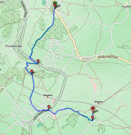
This still wasn’t enough for me to be able to piece the route together, so this afternoon Darren & I drove our bikes up to Kirkburton to find the start of the new routes. The off-road route starts on Box Ings Lane opposite Kirkburton Health Centre (on a Sunday afternoon we felt it was reasonable to use the Health Centre car park) and is labelled as 11.5 miles to Millhouse Green. We spotted the start of the on-road route a little further north down the main road nearer the centre of Kirkburton, that one is labelled as 9.5 miles.
Unfortunately we were unimpressed with the off-road route from the start. I missed the second sign and cycled up a driveway rather than the bridleway, fortunately Darren saw it but the path was much more of a ‘footpath’ than we had expected, very rocky and uphill and we ended up walking fairly quickly. Our bikes are hybrids but they weren’t really up to the roughness of the path and in places it was very narrow. We only bumped into a couple of dog walkers though. The path got better as we went on, turned into a farm track shortly before meeting Penistone Road. There is a short on-road section down to Dam Hill. The second section of off-road track is even worse than the first, before it turns into Long Lane which is a decent path with good views through farmland that takes you to Shepley.
The route passes through Shepley on roads (Field Head, Lydgate Lane, a short bit of the main Abbey Road, and on to The Knowle) and leads onto a bridleway marked as High Moor Lane on some maps. This started off as what I think was supposed to be a grass track (no grass,very muddy) and then the downhill section was like riding down a stream. A bit too exciting for me, and my bike wasn’t really up to it. When we hit the left turn onto Copley Lane at the bottom we decided we’d had enough even though we’d only covered 3 and a bit miles of the trail. We definitely weren’t going to retrace our steps to go back upstream so we gave up following the trail for the day. We may try again in the future (hence ‘Part 1’ in the post title!), but we won’t be trying this section again. We carried on up Near Bank to Shelley, found a bench with a view for our picnic and took a quick spin back down Huddersfield Road to the car.
We didn’t bump into any other cyclists on this part of the trail, which didn’t really surprise us given what we found. I would have enjoyed walking it, but it wasn’t particularly suitable for family cycling without mountain bikes. I’m more inclined to try out the on-road route next time!
In case it helps anyone else, here is our route along the first part of the trail from Kirkburton to Shelley, plotted on OpenCycleMap using BikeRouteToaster: